The neighbor’s two dogs accompanied me on my after work walk. Here’s one of them.

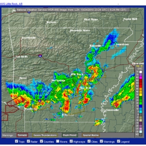
Mother Nature is making up for lost time, after months of dry weather, sending wave after wave of storms on Oct. 24.
The following day, the National Weather Service confirmed a weak tornado:
000
NOUS44 KLZK 252012
PNSLZK
ARZ003>007-012>016-021>025-030>034-037>047-052>057-062>069-260600-

PUBLIC INFORMATION STATEMENT
NATIONAL WEATHER SERVICE LITTLE ROCK AR
315 PM CDT MON OCT 25 2010

...EF0 TORNADO CONFIRMED IN SOUTHWEST PULASKI COUNTY...

TODAY...A SURVEY TEAM FROM THE NATIONAL WEATHER SERVICE IN LITTLE
ROCK CONFIRMED THAT AN EF0 TORNADO TOUCHED DOWN IN SOUTHWEST PULASKI
COUNTY LATE SUNDAY AFTERNOON. EF0 TORNADOES ARE THE WEAKEST
TORNADOES ON THE ENHANCED FUJITA SCALE...AND HAVE WINDS BETWEEN 65
AND 85 MPH.

THE TORNADO WAS ON THE GROUND FOR 0.77 MILE...FROM 3 MILES
WEST-NORTHWEST OF CRYSTAL VALLEY TO 2.7 MILES NORTHWEST OF CRYSTAL
VALLEY. THE MAJORITY OF THE DAMAGE WAS ON CRYSTAL VALLEY RD. ABOUT
1/2 MILE SOUTH OF LAWSON RD.

A FEW TREES WERE BLOWN DOWN...A NUMBER OF LARGE LIMBS WERE BLOWN
DOWN...AND PART OF A BARN ROOF WAS BLOWN OFF.

STORM DAMAGE AT E. ROOSEVELT AND DUGAN IN EAST LITTLE ROCK WAS ALSO
SURVEYED. HERE...A ROOF WAS BLOWN OFF AN INDUSTRIAL BUILDING...
KNOCKING DOWN POWER LINES AND POWER POLES. THIS DAMAGE WAS CAUSED BY
THUNDERSTORM WINDS...NOT A TORNADO.

DAMAGE AROUND THE 4000 BLOCK OF BASELINE RD. AND ON BRUNO RD. IN
SOUTHWEST LITTLE ROCK WAS ALSO SURVEYED. HERE...A NUMBER OF LARGE
LIMBS WERE BLOWN DOWN...A TREE FELL ON A HOUSE...AND SOME SHINGLES
WERE BLOWN OFF THE ROOFS OF HOUSES. THIS DAMAGE WAS CAUSED BY
THUNDERSTORM WINDS...NOT A TORNADO.

$$

When moisture from the warm Gulf of Mexico meets cold air from the north and west, severe thunderstorms are likely. Sometimes, they give birth to tornadoes. One such storm cropped up mid-afternoon today. Here on Round Mountain, we had a front row seat as the wall cloud moved eastward, pelting us with pea-sized hail and cracking the sky with frequent lightning.
The National Weather Service is still receiving damage reports. Some 15,000 people are reported without power, with trees down, one car overturned with children inside (the children were rescued and reported to be OK, but probably scared out of their wits), and damage to buildings downtown.


After a long, thirsty summer, we welcomed a widespread rain last night. It’s been a long time since there was enough moisture to see droplets cling to petals, leaves and even insects. The cooler fall temperatures are also encouraging regrowth. Volunteer dill, sorrel and clover are all coming back to life.


Checked in to the volcano cam on Jan. 15 and voila! The mountain reappeared!

We were fortunate enough to visit Mount St. Helens in 1998, but haven’t made it back since then. Volcano fans can enjoy a virtual visit, thanks to the National Park Service webcams. However, even web technology has its limits. Moisture won the day today.

My adventurous cousin has provided more photos from her extensive sojourn in China, this time in Xi’an in central China, whose settlement dates back at least to the neolithic.


